language

中文 English

关于我们
CASE
Power Grid Traffic Intelligent Digital City Ocean
Geological disaster monitoring
Business Challenge
The inspection environment is extremely dangerousThe terrain in disaster-prone areas is steep and the rock and soil are loose. During rainstorm weather, patrols are prone to encounter burial, impact, and injury, posing a high risk of casualties.
The coverage of manual inspection is limitedGeohazard sites are widely distributed and the terrain is complex, which limits the artificial inspection routes and reduces the inspection frequency; deep and concealed hazards are difficult to detect.
Multi-source data cannot be analyzed in a linked mannerVarious relevant data are scattered and lack integrated analysis; relying on manual pre-judgment, early warning lags behind, making it difficult to predict disaster trends.
The operation and maintenance costs in remote areas are highThe disaster-stricken areas are remote, making manual inspection of transportation infrastructure and time-consuming. In severe weather conditions, frequent inspections are required, which are inefficient and require significant investment.
Weak early warning capability for sudden disastersDisasters break out suddenly, and due to the lack of all-weather real-time monitoring, it is difficult to detect anomalies in advance. As a result, early warning and evacuation are not timely, leading to heavy losses.
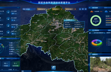
Solution Introduction With "artificial intelligence + integrated space-earth geological sensing" as the core, multiple technologies are integrated to build a geological disaster monitoring system with full coverage and real-time early warning, achieving dynamic monitoring and early warning of hidden dangers. At the same time, focusing on the "last mile" of closed personnel management after the occurrence of geological disasters, we aim to open up the end-to-end links of closed control, personnel investigation, and emergency evacuation, minimizing the risk of secondary disasters.
Dynamic monitoring of landslide/collapse bodiesVarious sensors are deployed to monitor displacement, cracks, and soil moisture, and satellite and drone technologies are utilized to capture surface deformation anomalies.
Special monitoring of debris flow gulliesDeploy multiple types of monitoring equipment to monitor rainfall, mud level, flow velocity, etc., and construct a model to predict the risk of outbreak.
Integrated perception of air, space, and groundThe combination of satellite surveys, drone inspections, and precise ground monitoring achieves three-dimensional coverage of the entire area.
Big data intelligent early warning platformIntegrate multi-source data, build predictive models with AI, implement graded early warning and push information in a coordinated manner, to support emergency response.
Big data intelligent early warning platformClearly define the division of enclosed areas, equip with intelligent control devices, and fortify the "last mile" defense line for personnel management to prevent secondary casualties.
Solution Value
Avoid life risks associated with manual inspectionIntelligent devices replace manual labor in high-risk areas, eliminating various safety accidents and ensuring the safety of monitoring personnel.
Achieve all-weather monitoring across the entire domainUnrestricted by terrain and weather, it provides 7x24-hour full coverage, significantly enhancing monitoring efficiency.
Early warning to reduce disaster lossesIntegrate and analyze data, provide early warning of risks, support personnel and property evacuation, and reduce losses.
Reduce the comprehensive cost of disaster prevention and mitigationReduce labor and exploration investment, implement precise governance, and avoid blind investment.
Build a solid defense line for the management of isolated personnelBreak through the "last mile" of personnel management, achieve a closed-loop control system, prevent secondary casualties, and ensure the safety of affected personnel.